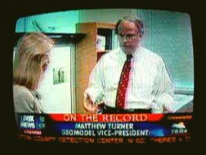
Greta Van Susteren of Fox News came to the office of GeoModel, Inc. to obtain information on ground penetrating radar (GPR). Greta Van Susteren interviewed Matthew Turner, GeoModel's ground penetrating radar expert who is a licensed professional geologist with over twenty years of GPR experience. GeoModel, Inc. gave a demonstration of the GPR equipment and the GPR images that can be obtained. Fox News' Greta Van Susteren was interested in information about the ability of ground penetrating … [Read more...]
Case Study: Historic Cemetery in North Carolina

In May 2021, GeoModel, Inc. conducted a ground penetrating radar (GPR) survey to locate unmarked graves in an historic church cemetery near Black Mountain, North Carolina. Over one acre was scanned for unmarked graves. Many residents remember family members being buried in the cemetery in family plots, but the exact locations were not known. GeoModel’s nationally known expert grave locator, Matthew Turner, PG, traversed the cemetery using GPR and located the unmarked graves. An excellent … [Read more...]
Historic Cemetery Survey in South Lake Tahoe, California

In 2020, GeoModel, Inc. conducted a Ground Penetrating Radar (GPR) survey at the Historic Pioneer Cemetery located in South Lake Tahoe, California. GeoModel, Inc. located and confirmed 105 burials in the cemetery, during the survey. Members of the Lake Tahoe Historic Society are shown with Matthew Turner, PG, of GeoModel, Inc., in the photo above. … [Read more...]
CNN – GeoModel, Inc. Interview

Matthew Turner of GeoModel, Inc. was on the CNN Wolf Blitzer television news reports program. Matthew Turner was interviewed by a CNN national security correspondent at the GeoModel office. CNN was interested in the use of ground penetrating radar (GPR) to locate subsurface objects. Matthew Turner discussed the operating principles of ground penetrating radar and, using the GPR equipment, demonstrated the ability of ground penetrating radar to locate buried objects, such as utilities, deep … [Read more...]
GeoModel, Inc. Electromagnetic Conductivity Survey (EM Survey) at a Colorado Landfill

GeoModel, Inc. conducted an Electromagnetic Conductivity survey (EM survey) at a landfill site in Colorado. The client needed to locate the boundaries of the landfill cells. The EM survey successfully delineated numerous landfill cells, which are high in conductivity (increasing in value from yellow, orange, red, to pink colors). Background (neutral) EM survey readings are represented by green and light blue colors. Dark blue colors can represent very low background EM survey readings … [Read more...]
Urenco USA Facility, Eunice, New Mexico
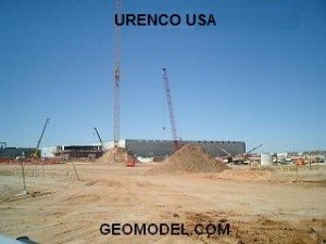
GeoModel, Inc. completed a nearly three-year utility location contract at the Urenco USA Uranium Enrichment Facility near Eunice, New Mexico. The GeoModel, Inc. contract was for marking utilities in the field and creating 400 as-built utility maps in AutoCAD format for the one square mile facility. These maps were used by the numerous on-site construction companies and facilities management for locating utilities prior to excavation activities. GeoModel, Inc. used ground penetrating radar … [Read more...]
Locating Underground Sinkholes

Are sinkholes common in your state? Is there a sinkhole in your own neighborhood? If so, you’re probably wondering if your property will be impacted, and what you can do about it. Using ground penetrating radar (GPR), GeoModel, Inc. can conduct sinkhole investigations without disturbing your property. What is a sinkhole? A sinkhole (also known as a cenote, sink, sink-hole, shakehole, swallet, swallow hole, or doline) is a depression or hole in the ground caused by some form of collapse of the … [Read more...]
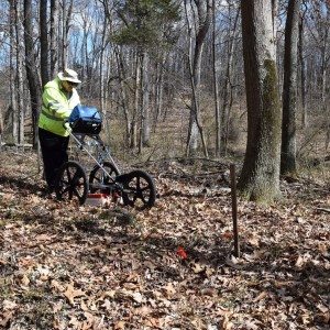
Stanton Family Cemetery Survey Conducted by GeoModel, Inc.

Earlier this year in 2020, GeoModel, Inc. conducted a grave locating survey at the Stanton Family Cemetery in Buckingham County, Virginia. The cemetery is approximately 65 feet by 68 feet and contains a total of 49 burials. The cemetery grave survey was conducted by Matthew Turner, a GeoModel, Inc. nationally-known, Licensed Professional with a Master's degree and over 20 years of experience in grave location. Mr. Turner confirmed the 36 known burials and located an additional 13 unmarked … [Read more...]
Cemetery Preservation Work Continues
GeoModel, Inc.'s Matthew Turner conducted a ground penetrating radar (GPR) survey to help locate gravesites in an African-American graveyard in the woods across from the Leesburg Executive Airport, south of Leesburg, Virginia. … [Read more...]
How to Locate Underground Utilities
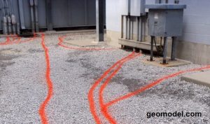
How to Locate Underground Utilities By Matthew Turner, PG Vice President GeoModel, Inc. www.geomodel.com Locating underground utilities should be performed by an experienced licensed professional with many years of locating utilities. Many times, buried utilities are located by people from Low-Cost Locating Companies with only little experience and with limited locating equipment, which can lead to unidentified utilities that will be hit during excavation. Many people have been … [Read more...]