Using a variety of geophysical survey methods, GeoModel, Inc. can conduct landfill detection surveys to locate and delineate the extent of a landfill up to 30 feet deep.
Our instruments can detect and determine the size and extent of:
- Burial trenches
- Landfill cells and waste pits
- Buried metal (i.e. steel drums) areas
- Inorganic contaminant or salt water (brine) plumes (landfill leachate)
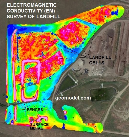
One of the methods that GeoModel, Inc. uses for buried landfill detection and burial trench location is an electromagnetic conductivity survey, also called terrain conductivity survey or EM survey. For landfill delineation and burial trench detection, electromagnetic conductivity can measure both the variations in ground conductivity and the amount of buried metal in a landfill or burial trench.
Ground conductivity in landfill cells and burial trenches can increase due to buried metal, such as steel drums, or due to high total dissolved solids or conductive groundwater impacts, making landfill detection relatively easy.
Results from an electromagnetic conductivity (EM) survey for landfill detection is shown below. The orange and red colors represent buried metal and high conductivity debris in the landfill cells and trenches. The blue and green colors represent lower conductivity areas outside of the metal-containing landfill cells and trenches.
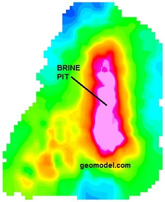
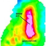
EM surveys can also be useful for delineation of any conductive or inorganic groundwater impact plumes emanating from the landfill or burial trench and migrating downgradient of, and possibly offsite from, the landfill. GeoModel, Inc. can easily conduct contaminant plume mapping at a landfill, burial trench, or brine pit site.
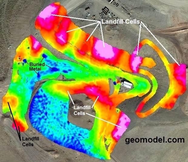
The EM survey results below show how an electromagnetic conductivity survey can be used for mapping the extent of contaminant plumes emanating from landfill cells. The landfill cells are generally represented by very high conductivity areas indicated by pink colors.
Areas of high conductivity groundwater are indicated by warm tones, with the least impacted groundwater represented by yellow and the most contaminated groundwater areas shown in red.
Areas of low conductivity groundwater are indicated by cool colors, with green representing low conductivity and blues representing background levels of conductivity. Due to the sine curve nature of EM data, some small areas of dark blue represent buried metal.
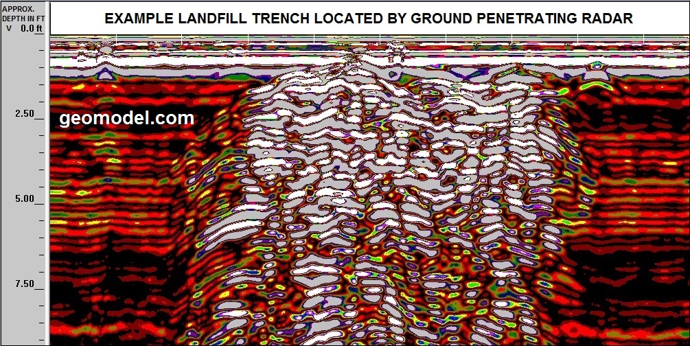
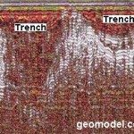
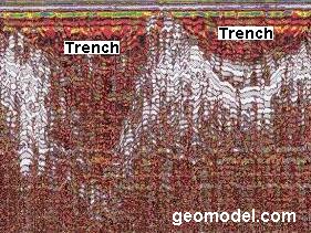
GeoModel, Inc. also uses ground penetrating radar (GPR) for landfill detection, and to detect waste pits and burial trenches. GPR utilizes an antenna (or transducer) to introduce signals into the ground that reflect from buried landfill materials and converts the signals into an image of the subsurface onto a field computer screen.
An example of a GPR profile showing a cross-section of a landfill trench is shown below. This landfill had mixed debris with few large objects to observe in the data. The extent of the landfill trench, however, is clearly seen. GPR images can assist in the determination of not only the extent of a landfill, but also the depth of landfill cells and burial trenches. The trench below is at least nine feet deep.
Additional images below show two landfill burial trenches, along with an example of a color contour image, mapping a leachate plume emanating from a landfill. An example ground conductivity color contour map of a brine pit, and the salty groundwater plume moving off to the southwest, is also shown below.
Additional Images
Click on an image for a larger view.
-
- Buried Trench example
-

- Landfill Detection example

-
- Brinepit example