Electromagnetic conductivity surveys, terrain conductivity surveys, or EM surveys measure the conductivity of the subsurface which includes soil, groundwater, rock, and objects buried in the ground. GeoModel, Inc. has conducted numerous electromagnetic conductivity surveys, terrain conductivity surveys, and EM surveys nationwide and worldwide using EM instruments for various applications.
Electromagnetic Conductivity surveys, Terrain Conductivity surveys and EM surveys, are useful for detecting and investigating landfills, delineating conductive ground water (contamination plume mapping), defining lateral changes in lithology ( sandy soil versus clay soil), and locating buried metal objects (buried tanks, drums, and utilities). Terrain conductivity surveys, electromagnetic conductivity surveys, and EM surveys are conducted by hand or are vehicle mounted and pulled along.
EM surveys, electromagnetic conductivity surveys, and terrain conductivity surveys are valuable in real estate purchases, land assessments and contamination assessment studies. EM surveys can be used to locate water producing fractures in bedrock or to detect sinkholes that may be associated with increased water drainage. EM Surveys by GeoModel, Inc. can locate sources of water on properties that have intermittent or persistent standing water, flooded ground, waterlogged or soggy soils, or other wetness problems, due to naturally high ground water table, leaky water pipes, water seepage, poor drainage, buried streams, or natural surface springs.
Terrain conductivity surveys, electromagnetic conductivity surveys, and EM surveys can delineate landfill cells and determine if contaminated water (landfill leachate) is flowing offsite from the landfill. Electromagnetic conductivity surveys can map areas of buried metal common in landfills. A Terrain Conductivity survey or EM survey should be conducted prior to any large real estate purchase to preclude any hidden buried debris, USTs, sinkholes, or landfill material.
A Terrain Conductivity survey can be carried out using a Geonics EM31 Terrain Conductivity meter. By using GPS and a data logger, the EM31 survey can collect considerable amounts of data over many acres of land. If locations of smaller, more shallow buried metal objects are to be determined, then a Geonics EM61 metal detector can be used to survey and map many acres of land for smaller buried metal objects.

 Electromagnetic conductivity surveys, terrain conductivity surveys, and EM surveys are rapid and very accurate. The instruments are easily carried or moved around the site and are used for a variety of purposes. Underground metal petroleum tanks can be located, metal underground utility pipes can be detected, contaminated groundwater plumes can be mapped, and clay units can be identified. GeoModel, Inc. uses the new EM metal detection system which is twice as accurate as the standard electromagnetic conductivity survey, terrain conductivity survey, or EM survey metal detection system.
GeoModel, Inc.’s geophysicists can perform an EM survey, terrain conductivity survey, or electromagnetic conductivity survey anywhere in the world and with short notice. Survey costs are reasonable.
Applications of buried metal detection and electromagnetic conductivity surveys (EM surveys) or terrain conductivity surveys include:
- Buried metal objects
- Metal underground storage tanks (USTs)
- Buried metal drums
- Buried metal utility lines
- Landfills and burial trenches
- Contaminant plume mapping
- Sinkholes
- Lateral changes in soil lithology
- Bedrock fractures
- Mining and minerals
- Archaeological mitigation
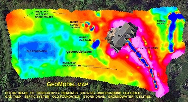
For a color-contoured GeoModel Map, mapping is done automatically using a vehicle or ATV driven system or a hand-carried method, with GPS positioning. Results of the electromagnetic conductivity survey, terrain conductivity survey or EM survey can be obtained in a short time period, making our system cost-effective for large industrial sites, as well as for smaller sites. Metal utility lines, and most other conductive or electrical utility lines, are mapped using our unique technique.

Electromagnetic Conductivity survey (EM survey) or Terrain Conductivity survey at a landfill to locate landfill cells and trenches, below:
