GeoModel

Contact Us

geomodel@geomodel.com703-777-9788
  • Home
  • Applications
    • Utility Location
    • Cemetery Mapping and Grave Scanning Services
    • Sinkhole and Void Detection
    • Underground Storage Tank Detection and Buried Drum Detection
    • Geology, Bedrock and Geologic Hazards
    • Landfill Detection, Burial Trench Delineation, and Contaminant Plume Mapping
    • Concrete and Rebar Inspection
    • Archaeological and Environmental Studies
    • Brine Pits, Reserve Pits, Leaking Brine Pipes
  • Methods
    • What is Ground Penetrating Radar
    • Electromagnetic Conductivity Survey, Terrain Conductivity Survey, and EM Survey
    • Magnetometer Surveys
    • Resistivity or Surface Resistivity
  • Case Studies
  • News
  • Articles
  • About
  • Contact

Resistivity or Surface Resistivity

Surface resistivity is another non-destructive geophysical survey method used to investigate subsurface conditions. Surface resistivity can produce a detailed profile of the subsurface even in clay soils. Low ground resistivity is associated with clay soils, moist soils, buried metal, and other conductive materials. High ground resistivity is common in sandy soils, dry soils, and other relatively non-conductive subsurface materials.

Application of the surface resistivity method requires that an electrical current be injected into the ground by surface electrodes. The resulting potential field (voltage) is measured at the surface by a voltmeter between electrodes.


The apparent resistivity of the subsurface materials can be calculated by knowing the electrode spacing, geometry of the electrode positions, applied current, and measured voltage. Surface resistivity measurements are reported in units of ohm-meters or ohm-feet. The apparent resistivity values are entered into a computer program that calculates the vertical geoelectric sections or columns for each sounding location.

The depth of the resistivity measurement is related to the spacing of the electrodes and may vary depending on the subsurface conditions. The surface resistivity unit has a self-contained transmitter capable of obtaining data to about 30 meters (100 feet) deep, using self-contained, rechargeable batteries.

Surface resistivity measures the electrical resistivity of the subsurface materials, which include soil and groundwater characteristics, from point survey stations at the ground surface. Surface resistivity can be used to study lateral changes and vertical cross sections of the natural hydrogeological setting.

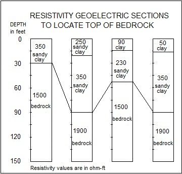
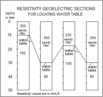
Two cross-sectional diagrams of vertical columns of apparent surface resistivity geoelectric sections are shown below. The first shows the results of a surface resistivity survey to locate top of bedrock, and the second shows the geoelectric sections for locating the ground water table.


Surface resistivity can also be used to study contamination of soil and groundwater (such as at landfill sites) and to locate buried objects.

GeoModel, Inc. personnel have conducted numerous surface resistivity surveys and investigations. All surface resistivity surveys are conducted or supervised by registered professional geologists. GeoModel, Inc. can travel nationwide or worldwide to conduct a surface resistivity survey.

Surface Resistivity Applications:

  • Water table mapping
  • Soil type mapping
  • Bedrock depth
  • Soil and groundwater contamination
  • Saltwater/freshwater interface
  • Mapping clay layers or sand deposits
  • Buried object location
  • Mineral exploration
  • Fracture location

Latest Project

Example of 6 Unmarked Graves Located by GeoMdoel Inc.

Case Study: Historic Cemetery in North Carolina

In May 2021, GeoModel, Inc. conducted a ground penetrating radar (GPR) survey to locate unmarked graves in an historic church cemetery near Black Mountain, North Carolina.  Over one acre was scanned … [read more]

GeoModel News

Historic Cemetery Survey in South Lake Tahoe, California

In 2020, GeoModel, Inc. conducted a Ground Penetrating Radar (GPR) survey at the Historic Pioneer Cemetery located in South Lake Tahoe, California. GeoModel, Inc. located and confirmed 105 burials in … [read more]

Stanton Family Cemetery Survey Conducted by GeoModel, Inc.

Earlier this year in 2020, GeoModel, Inc. conducted a grave locating survey at the Stanton Family Cemetery in Buckingham County, Virginia.  The cemetery is approximately 65 feet by 68 feet and … [read more]

GeoModel

All GPR surveys are conducted or supervised by:

  • Certified Professional Geologists with More Than 20 Years of Experience
  • 40-Hour OSHA Hazwoper-Trained Professionals
  • ISNetworld Member Company
  • Operators using FCC-approved Equipment
  • Field crews available nationwide
  • Woman-Owned Small Business (WBE)

Quicklinks

  • What is Ground Penetrating Radar
  • Utility Location
  • Cemetery and Grave Location and Mapping
  • Sinkhole and Void Detection
  • Underground Storage Tank Detection and Buried Drum Detection
  • Geology, Bedrock and Geologic Hazards
  • Landfill Detection, Burial Trench Delineation, and Contaminant Plume Mapping
  • Concrete and Rebar Inspection
  • Archaeological and Environmental Studies
  • Brine Pits, Reserve Pits, Leaking Brine Pipes

Connect With Us

Contact Us
geomodel@geomodel.com
703-777-9788
  • Facebook
  • LinkedIn
© Copyright 2014 GeoModel, Inc. All Rights Reserved · Small Business Websites by 5.12 Design Lab · Admin
▲