GeoModel

Contact Us

geomodel@geomodel.com703-777-9788
  • Home
  • Applications
    • Utility Location
    • Cemetery Mapping and Grave Scanning Services
    • Sinkhole and Void Detection
    • Underground Storage Tank Detection and Buried Drum Detection
    • Geology, Bedrock and Geologic Hazards
    • Landfill Detection, Burial Trench Delineation, and Contaminant Plume Mapping
    • Concrete and Rebar Inspection
    • Archaeological and Environmental Studies
    • Brine Pits, Reserve Pits, Leaking Brine Pipes
  • Methods
    • What is Ground Penetrating Radar
    • Electromagnetic Conductivity Survey, Terrain Conductivity Survey, and EM Survey
    • Magnetometer Surveys
    • Resistivity or Surface Resistivity
  • Case Studies
  • News
  • Articles
  • About
  • Contact

Utility Location

GeoModel, Inc. has over 25 years of experience locating underground utilities nationwide. GeoModel, Inc.’s professional utility location experts use only the latest equipment and methods to locate underground utilities. These utility location methods include ground penetrating radar (GPR), electromagnetic conductivity (EM) and frequency location. GeoModel, Inc. is known for locating utilities and pipelines that other locating companies cannot.


GeoModel-Multi-Frequency-Locator GeoModel-Metal-Detector

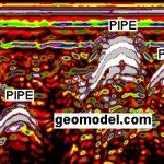
Ground penetrating radar can locate underground utilities that other only metal-detecting instruments cannot. GPR can locate plastic or PVC pipe and other types of nonconductive pipe such as concrete and terra cotta pipe in most conditions. GPR yields an underground image of the pipes and utilities so that the utility location can be marked on the ground. Images of an example GPR profile from an underground utility location survey and the ground penetrating radar cart are seen below:

Numerous underground pipes located by GeoModel using GPR

GeoModel plastic GPR cart for utility detection

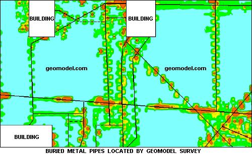
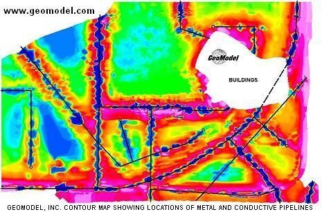
GeoModel, Inc. also uses electromagnetic conductivity (EM) instruments for utility location. An EM survey can locate public and private utilities that are conductive, including all types of metal pipes and electrical duct banks to depths of up to 20 feet deep for larger diameter pipes or conduits. GPS and a data logger can be combined with the EM utility location detector to produce color maps of the subsurface metal, electrical, and other conductive underground utilities on a site.  GeoModel can overlay the EM color contour image onto a Google Earth file for utility location and pipeline location and mapping, as seen below:

Frequency locators are also used by GeoModel, Inc. to locate underground utilities using a specific frequency applied to a metal pipe or electrical utility by employing a frequency transmitter. This transmitted frequency can be traced for considerable distances across a site for underground utility location and marking.

GeoModel Utility Locating

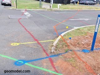
GeoModel, Inc. conducts utility line location survey services using a combination of all these methods, which are complementary in their capabilities, to detect buried utilities. GeoModel, Inc. is often hired to locate and mark buried utilities and pipelines that other utility locating companies have not found. GeoModel, Inc. provides utility and pipeline detection services by marking the locations of detected utilities and pipes on the ground surface with survey flags or marking paint in the standard industry colors or a single color for unknown buried utility locations.

GeoModel, Inc. Utility Mapping and Pipeline Mapping

GeoModel, Inc. Utility Location and Pipeline Location Marking


Contact GeoModel, Inc. today for our underground utility location services or for a 4-way sweep of your property or facility.

Additional Images

Click on an image for a larger view.

Utility Location Image by GeoModel, Inc.
Water Pipes and Electrical Lines Located by GeoModel
GeoModel, Inc. uses deep metal detection to locate metal pipes

Latest Project

Example of 6 Unmarked Graves Located by GeoMdoel Inc.

Case Study: Historic Cemetery in North Carolina

In May 2021, GeoModel, Inc. conducted a ground penetrating radar (GPR) survey to locate unmarked graves in an historic church cemetery near Black Mountain, North Carolina.  Over one acre was scanned … [read more]

GeoModel News

Historic Cemetery Survey in South Lake Tahoe, California

In 2020, GeoModel, Inc. conducted a Ground Penetrating Radar (GPR) survey at the Historic Pioneer Cemetery located in South Lake Tahoe, California. GeoModel, Inc. located and confirmed 105 burials in … [read more]

Stanton Family Cemetery Survey Conducted by GeoModel, Inc.

Earlier this year in 2020, GeoModel, Inc. conducted a grave locating survey at the Stanton Family Cemetery in Buckingham County, Virginia.  The cemetery is approximately 65 feet by 68 feet and … [read more]

GeoModel

All GPR surveys are conducted or supervised by:

  • Certified Professional Geologists with More Than 20 Years of Experience
  • 40-Hour OSHA Hazwoper-Trained Professionals
  • ISNetworld Member Company
  • Operators using FCC-approved Equipment
  • Field crews available nationwide
  • Woman-Owned Small Business (WBE)

Quicklinks

  • What is Ground Penetrating Radar
  • Utility Location
  • Cemetery and Grave Location and Mapping
  • Sinkhole and Void Detection
  • Underground Storage Tank Detection and Buried Drum Detection
  • Geology, Bedrock and Geologic Hazards
  • Landfill Detection, Burial Trench Delineation, and Contaminant Plume Mapping
  • Concrete and Rebar Inspection
  • Archaeological and Environmental Studies
  • Brine Pits, Reserve Pits, Leaking Brine Pipes

Connect With Us

Contact Us
geomodel@geomodel.com
703-777-9788
  • Facebook
  • LinkedIn
© Copyright 2014 GeoModel, Inc. All Rights Reserved · Small Business Websites by 5.12 Design Lab · Admin
▲