GeoModel

  • Email Us
  • 703-777-9788
  • Home
  • Applications
    • Utility Location
    • Cemetery Mapping and Grave Scanning Services
    • Sinkhole and Void Detection
    • Underground Storage Tank Detection and Buried Drum Detection
    • Geology, Bedrock and Geologic Hazards
    • Landfill Detection, Burial Trench Delineation, and Contaminant Plume Mapping
    • Concrete and Rebar Inspection
    • Archaeological and Environmental Studies
    • Brine Pits, Reserve Pits, Leaking Brine Pipes
  • Methods
    • What is Ground Penetrating Radar
    • Electromagnetic Conductivity Survey, Terrain Conductivity Survey, and EM Survey
    • Magnetometer Surveys
    • Resistivity or Surface Resistivity
  • Case Studies
  • News
  • Articles
  • About
  • Contact

GeoModel, Inc. Electromagnetic Conductivity Survey (EM Survey) at a Colorado Landfill

November 14, 2019 by GeoModel, Inc.

GeoModel, Inc. conducted an Electromagnetic Conductivity survey (EM survey) at a landfill site in Colorado.  The client needed to locate the boundaries of the landfill cells.  The EM survey successfully delineated numerous landfill cells, which are high in conductivity (increasing in value from yellow, orange, red, to pink colors).

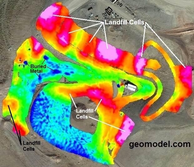
Background (neutral) EM survey readings are represented by green and light blue colors.  Dark blue colors can represent very low background EM survey readings or low conductivity spikes caused by buried metal debris.

The EM method was fairly rapid as the EM survey took just a few days to map several acres of landfill.  Exploratory drilling was conducted in the landfill area by the client to confirm the locations of the landfill cells delineated by the EM survey.

Filed Under: Case Studies

GeoModel

All GPR surveys are conducted or supervised by:

  • Certified Professional Geologists with More Than 20 Years of Experience
  • 40-Hour OSHA Hazwoper-Trained Professionals
  • Operators using FCC-approved Equipment
  • Field crews available nationwide
  • Woman-Owned Small Business (WBE)

Quicklinks

  • What is Ground Penetrating Radar
  • Utility Location
  • Cemetery and Grave Location and Mapping
  • Sinkhole and Void Detection
  • Underground Storage Tank Detection and Buried Drum Detection
  • Geology, Bedrock and Geologic Hazards
  • Landfill Detection, Burial Trench Delineation, and Contaminant Plume Mapping
  • Concrete and Rebar Inspection
  • Archaeological and Environmental Studies
  • Brine Pits, Reserve Pits, Leaking Brine Pipes

Connect With Us

Email Us
703-777-9788
  • Facebook
  • LinkedIn
© Copyright 2019 GeoModel, Inc. All Rights Reserved · Small Business Websites by Digital Fern · Admin
▲