GeoModel

Contact Us

geomodel@geomodel.com703-777-9788
  • Home
  • Applications
    • Utility Location
    • Cemetery Mapping and Grave Mapping Services
    • Sinkhole and Void Detection
    • Underground Storage Tank Detection and Buried Drum Detection
    • Geology, Bedrock and Geologic Hazards
    • Landfill Detection, Burial Trench Delineation, and Contaminant Plume Mapping
    • Concrete and Rebar Inspection
    • Archaeological and Environmental Studies
    • Brine Pits, Reserve Pits
  • Methods
    • What is Ground Penetrating Radar
    • Electromagnetic Conductivity Survey, Terrain Conductivity Survey, and EM Survey
    • Magnetometer Surveys
    • Resistivity or Surface Resistivity
  • Case Studies
  • News
  • Articles
  • About
  • Contact

Concrete and Rebar Inspection

When you need to know what is embedded within concrete, and/or the condition of the concrete, GeoModel, Inc. can conduct a real-time concrete inspection survey. Using ground penetrating radar (GPR), we can locate rebar, pipes, dowels, and plastic, and fiber optic conduits. Our concrete inspection survey can also detect voids within concrete slabs and under concrete slabs. We can scan concrete as thick as 12 to 18 inches and can report on the relative thickness, deterioration, and structural problems.


rebar200 rebarpnt
gpr1500cart

Our radar survey professionals can conduct a concrete inspection survey of:

  • Concrete block walls
  • Concrete floors
  • Concrete slabs
  • Airport runways
  • Tunnels
  • Abutments
  • Dams
  • Garages
  • Concrete roads and surfaces

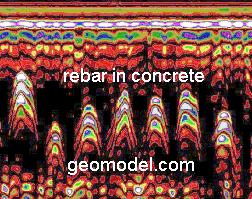
GeoModel uses 1500 MHz and 900 MHz antennas to locate voids, rebar, pipes, or other embedded components during concrete inspection. Our concrete inspector pulls the radar antenna along the concrete surface and observes the radar data on a computer. The image of the concrete is immediately seen on the computer screen and can be interpreted in real time. Rebar locations can be marked on the concrete in the field or the GPR data can be simultaneously recorded on the computer for further analysis, processing, and plotting on site maps back in the office.

Latest Project

GeoModel, Inc. Electromagnetic Conductivity Survey (EM Survey) at a Colorado Landfill

GeoModel, Inc. conducted an Electromagnetic Conductivity survey (EM survey) at a landfill site in Colorado.  The client needed to locate the boundaries of the landfill cells.  The EM survey … [read more]

GeoModel News

Historic Cemetery Survey in South Lake Tahoe, California

In 2020, GeoModel, Inc. conducted a Ground Penetrating Radar (GPR) survey at the Historic Pioneer Cemetery located in South Lake Tahoe, California. GeoModel, Inc. located and confirmed 105 burials in … [read more]

Stanton Family Cemetery Survey Conducted by GeoModel, Inc.

Earlier this year in 2020, GeoModel, Inc. conducted a grave locating survey at the Stanton Family Cemetery in Buckingham County, Virginia.  The cemetery is approximately 65 feet by 68 feet and … [read more]

GeoModel

All GPR surveys are conducted or supervised by:

  • Certified Professional Geologists with More Than 20 Years of Experience
  • 40-Hour OSHA Hazwoper-Trained Professionals
  • ISNetworld Member Company
  • Operators using FCC-approved Equipment
  • Field crews available nationwide
  • Woman-Owned Small Business (WBE)

Quicklinks

  • What is Ground Penetrating Radar
  • Utility Location
  • Cemetery and Grave Location and Mapping
  • Sinkhole and Void Detection
  • Underground Storage Tank Detection and Buried Drum Detection
  • Geology, Bedrock and Geologic Hazards
  • Landfill Detection, Burial Trench Delineation, and Contaminant Plume Mapping
  • Concrete and Rebar Inspection
  • Archaeological and Environmental Studies
  • Brine Pits, Reserve Pits

Connect With Us

Contact Us
geomodel@geomodel.com
703-777-9788
  • Facebook
  • LinkedIn
© Copyright 2014 GeoModel, Inc. All Rights Reserved · Small Business Websites by 5.12 Design Lab · Admin
▲