 Are sinkholes common in your state? Is there a sinkhole in your own neighborhood? If so, you’re probably wondering if your property will be impacted, and what you can do about it. Using ground penetrating radar (GPR), GeoModel, Inc. can conduct sinkhole investigations without disturbing your property.
What is a sinkhole?
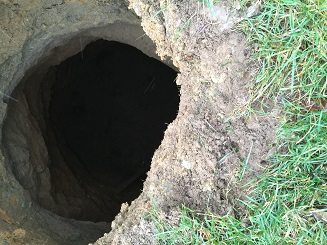
A sinkhole (also known as a cenote, sink, sink-hole, shakehole, swallet, swallow hole, or doline) is a depression or hole in the ground caused by some form of collapse of the surface layer. Whether formed by natural geologic processes or human activity, sinkholes can vary in diameter, depth and form. While some are soil-lined bowls, others can be bedrock-edged chasms.
Where do sinkholes form?
Sinkholes may be formed gradually or suddenly, and are found worldwide. Sinkholes can occur anytime and anywhere if subsurface conditions are just right for their formation. Some states in the US, however, are more prone to sinkhole formation, with the most damage from sinkholes occurring mainly in Florida, Texas, Alabama, Missouri, Kentucky, Tennessee and Pennsylvania.
How do I know if my property has a sinkhole?
While a sinkhole is forming underground, the land above usually stays intact for a while. Then, the space below ground just becomes too large to support the surface weight. A sudden, dramatic collapse ensues. How can a property owner know if there is a sinkhole forming — and what steps can they take to protect their home and belongings? First, it’s good to know the common signs of a sinkhole.
Nine common signs of sinkholes
- Cracks in interior joint areas, windows or doors
- Cracks in your exterior block or stucco
- Windows and doors become harder to close properly
- Depressions in your yard or the street or other yards near you
- Deep cracks and separation of paved concrete walks and drives
- Circular patches of wilting plants
- Sediment in your water
- Neighbors have had or confirmed possible sinkhole activity
- Observation of an actual cavity beginning to open
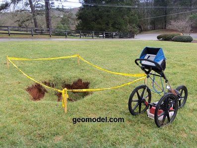
Locating sinkholes with GPR
Ground penetrating radar (GPR) is the best method for detecting and mapping out sinkholes below the earth’s surface. Seasoned GPR experts like those here at GeoModel, Inc. say that the best time to have a sinkhole survey conducted is before the collapse, while the subsurface void still exists. We recommend sinkhole location surveys in a variety of locations, including:
- Around and under homes and buildings
- Over roadways
- Over train tracks
- Over dams
- Over airport runways
- Any area where the subsurface materials are subject to collapse
Most of the sinkhole location surveys we’ve conducted are in karst limestone areas; however, we sometimes recommend sinkhole location investigations in areas with soft soil, in areas where water or sewer pipes have broken, or where mining or other surface or subsurface disturbance activities have occurred.
What to do if a sinkhole is forming on my property?
One thing you do not want to do is wait until a collapse occurs. There are methods to remediate a forming sinkhole before it opens up. To learn if your property has a sinkhole and for a detailed map that illustrates its extent (depth, diameter, form), contact GeoModel today