GeoModel

Contact Us

geomodel@geomodel.com703-777-9788
  • Home
  • Applications
    • Utility Location
    • Cemetery Mapping and Grave Scanning Services
    • Sinkhole and Void Detection
    • Underground Storage Tank Detection and Buried Drum Detection
    • Geology, Bedrock and Geologic Hazards
    • Landfill Detection, Burial Trench Delineation, and Contaminant Plume Mapping
    • Concrete and Rebar Inspection
    • Archaeological and Environmental Studies
    • Brine Pits, Reserve Pits, Leaking Brine Pipes
  • Methods
    • What is Ground Penetrating Radar
    • Electromagnetic Conductivity Survey, Terrain Conductivity Survey, and EM Survey
    • Magnetometer Surveys
    • Resistivity or Surface Resistivity
  • Case Studies
  • News
  • Articles
  • About
  • Contact

Trans-Alaska Pipeline, Alaska

September 29, 2014 by GeoModel, Inc.

Ground Penetrating Radar Survey

akpipel
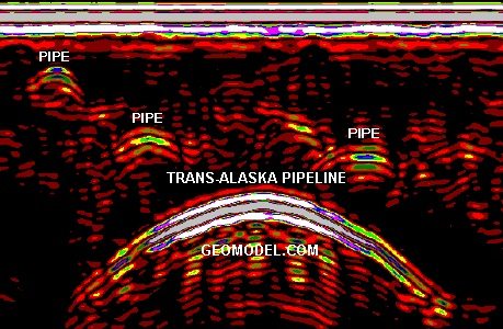
GeoModel, Inc. obtained ground penetrating radar images across several areas of the buried portion of the Trans-Alaska pipeline.

During the past several years, GeoModel, Inc. has conducted ground penetrating radar and other geophysical surveys at several Alyeska Pipeline Pump Stations.

Additional Images

Click on an image for a larger view.

ground penetrating radar image

Filed Under: Case Studies

Latest Project

Example of 6 Unmarked Graves Located by GeoMdoel Inc.

Case Study: Historic Cemetery in North Carolina

In May 2021, GeoModel, Inc. conducted a ground penetrating radar (GPR) survey to locate unmarked graves in an historic church cemetery near Black Mountain, North Carolina.  Over one acre was scanned … [read more]

GeoModel News

Historic Cemetery Survey in South Lake Tahoe, California

In 2020, GeoModel, Inc. conducted a Ground Penetrating Radar (GPR) survey at the Historic Pioneer Cemetery located in South Lake Tahoe, California. GeoModel, Inc. located and confirmed 105 burials in … [read more]

Stanton Family Cemetery Survey Conducted by GeoModel, Inc.

Earlier this year in 2020, GeoModel, Inc. conducted a grave locating survey at the Stanton Family Cemetery in Buckingham County, Virginia.  The cemetery is approximately 65 feet by 68 feet and … [read more]

GeoModel

All GPR surveys are conducted or supervised by:

  • Certified Professional Geologists with More Than 20 Years of Experience
  • 40-Hour OSHA Hazwoper-Trained Professionals
  • ISNetworld Member Company
  • Operators using FCC-approved Equipment
  • Field crews available nationwide
  • Woman-Owned Small Business (WBE)

Quicklinks

  • What is Ground Penetrating Radar
  • Utility Location
  • Cemetery and Grave Location and Mapping
  • Sinkhole and Void Detection
  • Underground Storage Tank Detection and Buried Drum Detection
  • Geology, Bedrock and Geologic Hazards
  • Landfill Detection, Burial Trench Delineation, and Contaminant Plume Mapping
  • Concrete and Rebar Inspection
  • Archaeological and Environmental Studies
  • Brine Pits, Reserve Pits, Leaking Brine Pipes

Connect With Us

Contact Us
geomodel@geomodel.com
703-777-9788
  • Facebook
  • LinkedIn
© Copyright 2014 GeoModel, Inc. All Rights Reserved · Small Business Websites by 5.12 Design Lab · Admin
▲