 What is GPR
Ground penetrating radar (GPR) detects underground features such as buried pipes, utilities, graves, or sinkholes.
GPR is a safe and unobtrusive and nondestructive way to detect underground objects and features without any excavation.
GPR can be used anywhere as it is a small, lightweight, and portable device. The GPR system can be moved along the ground with a hand cart, or mounted on a truck or ATV to survey quickly on larger sites.
Applications of GPR
GPR can locate hard to find pipes and utilities, locate unmarked graves in a cemetery, and detect sinkholes or voids under the ground. Click on one of the applications below for more information about using GPR to locate these objects or features:

Utility Locating Services
Unmarked Grave Location

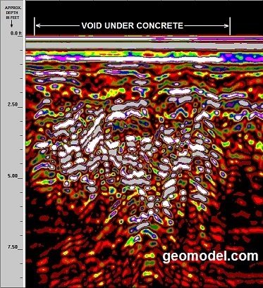
Sinkhole or Void Detection
How GPR Works
GPR uses electromagnetic pulses sent into the ground by a transducer (antenna). The returned signal creates an underground, cross-sectional image that represents buried features such as pipelines, graves, and sinkholes. GPR works best in dry, sandy soils, and has limited success in wet, clayey soils. GPR data is usually viewed in real time in the field but can be saved to a computer disk for further review and processing back in the office.
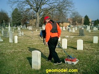
How GPR Locates Unmarked Graves at Cemeteries
Unmarked graves in cemeteries can be located using GPR. The GPR system is moved over the ground perpendicular to the known orientation of the graves to obtain the optimum signals. Graves interred between 2 to 20 years will show the most distinct (white and gray) GPR anomalies. Older graves will show less distinct GPR anomalies.


GPR Surveys for Locating Underground Utilities
GPR surveys can locate underground utilities that other locators cannot detect. GPR is especially important for locating PVC pipes that do not have tracer wires or locating tape. GPR should be used in addition to frequency locators and electromagnetic locators.

An underground pipe looks like an inverted U-shaped object in a GPR image when the GPR is run perpendicular to the pipe.

Underground utility lines detected by GPR and other GeoModel, Inc. locating equipment that most other locating companies do not have.
How GPR Transducers Work and How to Choose the Right One for the Job
GPR transducers (antennas) work by sending an electromagnetic signal into the ground. The depth of investigation of the GPR signal depends on the soil (or medium) type and the frequency of the GPR transducer.
A high frequency GPR antenna (1500 to 900 MHz) will yield great detail of the subsurface but only for a shallow depth (0 to 3 feet). These shallow GPR antennas are used mostly for concrete inspection and rebar or shallow void detection.
A lower frequency GPR antenna (400 to 200 MHz) will detect to deeper depths (1 to 30 feet), but have lower resolution beyond approximately 9 feet. These GPR transducers are used for locating underground utilities, detecting unmarked graves, and investigating for sinkhole activity or deep voids.
GPR Frequently Asked Questions (FAQ)
What is Needed for a GPR Survey?
For a GPR survey, GeoModel, Inc. needs to know the location (city and state) and dimensions (in feet by feet) of the survey area and the type of environment, such as urban or rural setting. We also need to know what the client is looking for, such as utilities or unmarked graves.
What kind of information do I get from a GPR survey?
GeoModel, Inc. provides the client with a real-time assessment of what is below the ground surface, be it naturally occurring or man-made. Since the GPR data is automatically recorded and displayed on the screen, GeoModel can playback the GPR data and review and explain the GPR data to the client in real-time.
Can GPR tell us the depth and size of the buried pipes?
Yes, GPR displays an image representing the size and depth of individual pipes. GeoModel can mark the ground with this size and depth information, in addition to the location of the buried pipes.
Are GeoModel, Inc. GPR surveys conducted by professionals?
Each GeoModel, Inc. GPR survey is conducted or supervised by licensed professionals with Master’s degrees and over 20 years of experience. Unlike some locating companies that have inexperienced personnel conducting their surveys, GeoModel only uses experienced personnel.
Are your GPR grave and cemetery surveys conducted by an expert?
The GeoModel, Inc. GPR grave and cemetery survey expert has over 20 years’ experience in the field. Our GPR cemetery and grave expert has been highlighted in numerous newspaper articles and has been interviewed by several television programs including CNN and Fox News.
GeoModel, Inc. Background
GeoModel, Inc. was started in 1991 to conduct GPR surveys in a cost-effective but comprehensive way. GeoModel has a 25-year track record of providing GPR surveying services that satisfy its customers’ needs.