GeoModel

Contact Us

geomodel@geomodel.com703-777-9788
  • Home
  • Applications
    • Utility Location
    • Cemetery Mapping and Grave Scanning Services
    • Sinkhole and Void Detection
    • Underground Storage Tank Detection and Buried Drum Detection
    • Geology, Bedrock and Geologic Hazards
    • Landfill Detection, Burial Trench Delineation, and Contaminant Plume Mapping
    • Concrete and Rebar Inspection
    • Archaeological and Environmental Studies
    • Brine Pits, Reserve Pits, Leaking Brine Pipes
  • Methods
    • What is Ground Penetrating Radar
    • Electromagnetic Conductivity Survey, Terrain Conductivity Survey, and EM Survey
    • Magnetometer Surveys
    • Resistivity or Surface Resistivity
  • Case Studies
  • News
  • Articles
  • About
  • Contact

Border Wall Geology and Geophysics

Building a Border Wall requires knowledge of all types of geological conditions and hazards that may be underneath the ground.  GeoModel, Inc. specializes in conducting geological surveys and geophysical surveys to map out the geology and delineate corresponding hazards.

Our firm was founded in 1991 and has always provided expert services in geologic consulting, geological surveying, geophysical surveying, and environmental consulting.  The company principals have over 50 years of combined experience as geological consultants and have conducted numerous geological surveying and geophysical surveying projects worldwide.  All geologic consultants at GeoModel, Inc. are registered or certified professional geologists.

ground penetrating radar for border wall bedrock investigation

To investigate the subsurface in the area of the border wall, GeoModel, Inc. can provide you with:

  • Geologic mapping of bedrock units
  • Determination of soil types and density (loose versus competent)
  • Location of underground utilities and pipelines
  • Detection of caves, sinkholes, and karst
  • Location of buried stream channels
  • Geologic hazards analysis
  • Geomorphology
  • Geological surveys
  • Geophysical surveys
  • Geological consultants with Professional Geologist (PG) certifications
  • Small, Woman-owned Business Enterprise (WBE) Company

shallow GPR for border wall geological survey
Shallow ground penetrating radar survey (less than 10 feet deep)


Deep GPR survey for border wall geophysical investigation
Deep ground penetrating radar survey (up to 30 feet deep)

Methods for Geologic Investigation Prior to Building a Border Wall

GeoModel, Inc. uses various methods for investigation of the geologic conditions in an area.  Visual observation, bedrock analysis, professional knowledge, and aerial photograph (air photo) analysis are some of these methods.  GeoModel, Inc. also uses various geophysical survey methods and advanced technology to assist in the investigation of geologic conditions at a site or property, including ground penetrating radar (GPR), electromagnetic conductivity (EM), and surface resistivity.

GPR for locating top of bedrock for installing a border wall
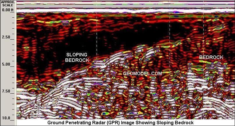
Ground penetrating radar profile of top of bedrock


Use of GPR to locate voids, karst, or sinkholes near border wall
Sinkhole detected by ground penetrating radar


EM survey to detect sinkhole activity near border wall
Sinkhole detected by electromagnetic conductivity (EM)

Latest Project

Example of 6 Unmarked Graves Located by GeoMdoel Inc.

Case Study: Historic Cemetery in North Carolina

In May 2021, GeoModel, Inc. conducted a ground penetrating radar (GPR) survey to locate unmarked graves in an historic church cemetery near Black Mountain, North Carolina.  Over one acre was scanned … [read more]

GeoModel News

Historic Cemetery Survey in South Lake Tahoe, California

In 2020, GeoModel, Inc. conducted a Ground Penetrating Radar (GPR) survey at the Historic Pioneer Cemetery located in South Lake Tahoe, California. GeoModel, Inc. located and confirmed 105 burials in … [read more]

Stanton Family Cemetery Survey Conducted by GeoModel, Inc.

Earlier this year in 2020, GeoModel, Inc. conducted a grave locating survey at the Stanton Family Cemetery in Buckingham County, Virginia.  The cemetery is approximately 65 feet by 68 feet and … [read more]

GeoModel

All GPR surveys are conducted or supervised by:

  • Certified Professional Geologists with More Than 20 Years of Experience
  • 40-Hour OSHA Hazwoper-Trained Professionals
  • ISNetworld Member Company
  • Operators using FCC-approved Equipment
  • Field crews available nationwide
  • Woman-Owned Small Business (WBE)

Quicklinks

  • What is Ground Penetrating Radar
  • Utility Location
  • Cemetery and Grave Location and Mapping
  • Sinkhole and Void Detection
  • Underground Storage Tank Detection and Buried Drum Detection
  • Geology, Bedrock and Geologic Hazards
  • Landfill Detection, Burial Trench Delineation, and Contaminant Plume Mapping
  • Concrete and Rebar Inspection
  • Archaeological and Environmental Studies
  • Brine Pits, Reserve Pits, Leaking Brine Pipes

Connect With Us

Contact Us
geomodel@geomodel.com
703-777-9788
  • Facebook
  • LinkedIn
© Copyright 2017 GeoModel, Inc. All Rights Reserved · Small Business Websites by 5.12 Design Lab · Admin
▲